We all know and love the present reassuringly familiar continents which are arranged in a reliable configurations. But nearly 750 million years ago, this configuration was not absolutely the same as it is now.
The Earth's land masses once situated as a gigantic supercontinent called 'Pangaea'. Over the due course of time, this gigantic mass of lithosphere cracked into pieces and began to slide away from each other. Chronologically the enormous blocks of landmasses displaced and came together again, and gradually formed the continents over almost 4.5 billion years.
Thenceforth, the present location of your hometown has done a lot more globetrotting than yours. A cool interactive map lets you explore, how much the location of your hometown has driven away and where it was located on 750 million years ago globe.
Brief about it
This interactive map is actually an animated three dimensional Ancient Earth Globe, developed by a palaeontologist Ian Webster. It is a combination of palaeogeographic maps which is a part of PALEOMAP Project, and database from GPlate which is known to be an open-source repository of geoscience data. It is needed to note that the PALEOMAP Project is a project, led by geologist and palaeogeographer Christopher R. Scotese, which aims to illustrate the development of plate tectonic of the Earth (including both of the ocean basins and the continents), along with the changing distribution of land and sea over past 1100 million years.
Check out the following link to get access to the interactive map
The combined tool will allow you to rewind the Earth going back as far as 750-million-year ago. Though it is not the entirety of our planet's history, rather it encompasses the four supercontinents, namely Pannotia, Gondwana, Laurentia, and Pangaea.
How does the Globe work
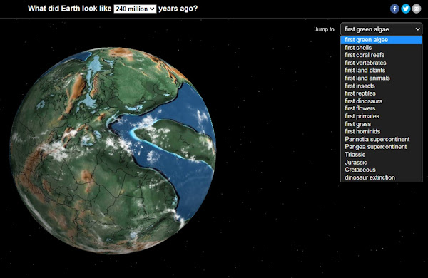
On the opening, the interactive map defaults to 240-million-year ago, which depicts the Early Triassic period. During this time, the oxygen level was significantly lower due to the extinction of many land plants. Small ancestors to birds, mammals, and dinosaurs were once again thriving. Over this time, the Pangaea did dominate the globe, which is the last known supercontinent just before the world as we know today.
You can look for what our Earth looked like during different events from a dropdown menu on the top-right side of the screen. But, if you like, you can also directly choose your own date from another dropdown menu at the top-centre of the screen.
Now, in the top-left corner, here is the part for which you have been waiting for. A search box will allow you to input a location that you can track across the different ages of the evolution of our planet. The black lines mark the borders as on today's earth.
It's always fun to look back ages and explore your hometown deep beneath the waves of evolution, along with the gradual appearance of mountain ridges you recognize as you march forward. Lastly it is a fine reminder that nothing stays the same, not even our own lovely planet Earth.


Post a Comment
Please do not enter any spam link in the comment box